
- 263
- 1 904 926
Convective Chronicles
United States
Приєднався 28 вер 2019
One-stop shop for in-depth forecast discussions and case studies for upcoming and past severe weather events across the United States, as well as easy-to-understand educational videos on meteorology with a focus on severe storms forecasting.
My name is Trey Greenwood, and I have been chasing and forecasting severe storms, tornadoes, and hurricanes for over a decade. I have also studied the weather extensively inside the classroom, earning a Bachelor's degree in Geography (Meteorology/Climatology emphasis) from Arizona State University and a Master's degree in Meteorology from the University of Oklahoma, where I used mobile radar data to study tornadoes under the guidance of tornado science pioneer Dr. Howie Bluestein.
Questions or comments about a specific video or meteorology topic? Leave a comment on the video or send me an email at convectivechronicles@gmail.com.
Forecast Discussion - May 19, 2024 - Wind-Driven Moderate Risk Centered on Kansas
For educational purposes only. If you live in the affected areas, please stay tuned to your local National Weather Service office for the most accurate and up-to-date information.
SPC has upgraded to a Moderate Risk (level 4/5) across parts of Kansas today. Initial supercells are expected to fire across western Kansas, quickly producing large to very large hail and strong outflow winds. Outflows are expected to congeal with time, fostering the growth of an intense MCS capable of yielding a swath of significant damaging winds. More isolated supercell development is possible across northwest Oklahoma; these storms will yield a large hail and damaging wind risk and maybe come well-structured by evening before being absorbed by the MCS.
Become a Patreon member today to support the channel: www.patreon.com/convectivechronicles
Facebook: ConvectiveChronicles
X: ConvChronicles
Instagram: convectivechronicles
Contents
0:00 Introduction, risk areas
2:46 Current conditions, observed data
13:24 Model analysis
31:45 Wrap-up
Переглядів: 4 201
Відео


Forecast Discussion - May 18, 2024 - Extended Stretch of Severe Weather Expected This Week
Переглядів 6 тис.2 години тому
For educational purposes only. If you live in the affected areas, please stay tuned to your local National Weather Service office for the most accurate and up-to-date information. A very active stretch of severe weather is expected to begin tomorrow (Sunday, May 19) and last through at least the end of the coming work week. SPC has outlined multiple days of severe weather potential from tomorro...

Pattern Change, Severe Weather Uptick Expected Next Week
Переглядів 7 тис.12 годин тому
For educational purposes only. If you live in the affected areas, please stay tuned to your local National Weather Service office for the most accurate and up-to-date information. After a bit of a lull in robust severe weather across the US, a prolonged pattern change is expected to begin early next week. In this video, we'll discuss the current state of the atmosphere and why we've been in and...

Forecast Discussion - May 8, 2024 - Widespread, Intense Severe Weather Expected Today
Переглядів 9 тис.День тому
For educational purposes only. If you live in the affected areas, please stay tuned to your local National Weather Service office for the most accurate and up-to-date information. SPC has upgraded to a Moderate Risk (level 4/5) across portions of Missouri, southern Illinois, and western Tennessee/Kentucky today. Multiple rounds of intense severe storms are expected today in this region with all...

Forecast Discussion - May 7, 2024 - Potent All-Hazards Risk Transitions East Today/Tomorrow
Переглядів 12 тис.День тому
For educational purposes only. If you live in the affected areas, please stay tuned to your local National Weather Service office for the most accurate and up-to-date information. Significant severe weather is expected to continue today and tomorrow across parts of the Midwest and Mid-South. For today, SPC has outlined an Enhanced Risk (level 3/5) for Indiana, Ohio, and Kentucky. Here, a mix of...
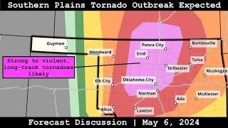
Forecast Discussion - May 6, 2024 - Southern Plains Tornado Outbreak Expected
Переглядів 26 тис.День тому
For educational purposes only. If you live in the affected areas, please stay tuned to your local National Weather Service office for the most accurate and up-to-date information. A regional significant severe weather outbreak is expected today, focused on southern Kansas into central Oklahoma, where SPC has upgraded to a rare High Risk (level 5/5). Multiple discrete supercells are expected to ...

Forecast Discussion - May 4, 2024 - Significant Severe Weather Expected Today, Next Week
Переглядів 9 тис.14 днів тому
For educational purposes only. If you live in the affected areas, please stay tuned to your local National Weather Service office for the most accurate and up-to-date information. Significant severe weather is expected today across west/southwest Texas, where SPC has outlined an Enhanced Risk (level 3/5). A few supercells should fire south of a cold front and east of a dryline near the Fort Sto...

Forecast Discussion - April 30, 2024 - Significant Severe Weather Returns to Central US
Переглядів 7 тис.14 днів тому
For educational purposes only. If you live in the affected areas, please stay tuned to your local National Weather Service office for the most accurate and up-to-date information. Significant severe weather will make a return to the central US over the next couple days. SPC has outlined Enhanced Risks (level 3/5) both today and tomorrow. TODAY: The Enhanced Risk extends from central Iowa into e...

Forecast Discussion - April 27, 2024 - Southern Plains Tornado Outbreak Possible Today
Переглядів 15 тис.21 день тому
For educational purposes only. If you live in the affected areas, please stay tuned to your local National Weather Service office for the most accurate and up-to-date information. A widespread severe weather outbreak is expected today across much of the central US. SPC has upgraded to a Moderate Risk (level 4/5) from southeast Kansas into much of Oklahoma and northwest Texas. An initial round o...
Forecast Update - April 26, 2024 - Significant Severe Weather Continues Today and Tomorrow
Переглядів 7 тис.21 день тому
For educational purposes only. If you live in the affected areas, please stay tuned to your local National Weather Service office for the most accurate and up-to-date information. Our well-advertised mutli-day severe weather sequence continues today (Friday, April 26) into this weekend. TODAY (FRIDAY): A complex setup is expected to unfold across the Midwest and southern Plains. SPC has outline...
Forecast Discussion - April 25, 2024 - Potential Severe Weather Outbreak Sequence Begins Today
Переглядів 8 тис.21 день тому
For educational purposes only. If you live in the affected areas, please stay tuned to your local National Weather Service office for the most accurate and up-to-date information. Our well-advertised mutli-day severe weather sequence is set to begin today (Thursday, April 25) as a series of troughs takes aim at a moist airmass draped across the Plains. TODAY (THURSDAY): Supercells will likely f...
Forecast Discussion - April 23, 2024 - Multi-Day, Significant Severe Weather Event on Tap This Week
Переглядів 9 тис.21 день тому
For educational purposes only. If you live in the affected areas, please stay tuned to your local National Weather Service office for the most accurate and up-to-date information. A multi-day stretch of potentially significant severe weather is on tap for a broad swath of the central and southern US, beginning in earnest on Thursday, April 25. A series of potent troughs will be making their way...
Forecast Discussion - April 18, 2024 - Significant Severe Weather Possible from Texas to the Midwest
Переглядів 4,4 тис.Місяць тому
For educational purposes only. If you live in the affected areas, please stay tuned to your local National Weather Service office for the most accurate and up-to-date information. The SPC has outlined an Enhanced Risk (level 3/5) today from central Missouri eastward to the western Ohio Valley and a broad Slight Risk (level 2/5) extending down into south Texas. A cold front will progress east, i...
Forecast Discussion - April 15, 2024 - Multi-Day Severe Weather Outbreak Begins Today
Переглядів 9 тис.Місяць тому
For educational purposes only. If you live in the affected areas, please stay tuned to your local National Weather Service office for the most accurate and up-to-date information. An outbreak of severe weather is expected to begin today across the Plains before shifting east into the Midwest/Mid-South tomorrow and Wednesday. The SPC has outlined an Enhanced Risk (level 3/5) across southern Sout...
Forecast Discussion - April 13, 2024 - Multi-Day Severe Weather Outbreak to Begin This Week
Переглядів 9 тис.Місяць тому
For educational purposes only. If you live in the affected areas, please stay tuned to your local National Weather Service office for the most accurate and up-to-date information. An outbreak of severe weather is expected to take place Monday and Tuesday (April 15 and 16) over a broad region from the southern Plains to the Midwest and Mid-South. The SPC has outlined an Enhanced Risk (level 3/5)...
Forecast Update - April 11, 2024 - Bimodal Severe Threat from the Midwest to the Southeast
Переглядів 2,7 тис.Місяць тому
Forecast Update - April 11, 2024 - Bimodal Severe Threat from the Midwest to the Southeast
Forecast Update - April 9, 2024 - Significant Severe Weather Outbreak Underway
Переглядів 8 тис.Місяць тому
Forecast Update - April 9, 2024 - Significant Severe Weather Outbreak Underway
Forecast Update - April 8, 2024 - Significant Severe Weather Sequence Begins This Eclipse Day
Переглядів 5 тис.Місяць тому
Forecast Update - April 8, 2024 - Significant Severe Weather Sequence Begins This Eclipse Day
Forecast Discussion - April 7, 2024 - Multi-Day Southern US Severe Threat + Eclipse Forecast #2
Переглядів 6 тис.Місяць тому
Forecast Discussion - April 7, 2024 - Multi-Day Southern US Severe Threat Eclipse Forecast #2
Eclipse Forecast #1 + Several Days of Severe Weather Ahead
Переглядів 4,8 тис.Місяць тому
Eclipse Forecast #1 Several Days of Severe Weather Ahead
The April 3-4, 1974, Tornado Super Outbreak: A Case Study
Переглядів 15 тис.Місяць тому
The April 3-4, 1974, Tornado Super Outbreak: A Case Study
Forecast Update - April 2, 2024 - Tornado Outbreak Possible from the Midwest to the Southeast
Переглядів 13 тис.Місяць тому
Forecast Update - April 2, 2024 - Tornado Outbreak Possible from the Midwest to the Southeast
Forecast Discussion - April 1, 2024 - Widespread, Intense Severe Weather Event Begins Today
Переглядів 12 тис.Місяць тому
Forecast Discussion - April 1, 2024 - Widespread, Intense Severe Weather Event Begins Today
Forecast Discussion - March 30, 2024 - Significant Severe Weather Threat to Begin April
Переглядів 9 тис.Місяць тому
Forecast Discussion - March 30, 2024 - Significant Severe Weather Threat to Begin April
Storm Chase Breakdown: Tracking Down a Beautiful, Dusty Tornado in Nebraska
Переглядів 7 тис.Місяць тому
Storm Chase Breakdown: Tracking Down a Beautiful, Dusty Tornado in Nebraska
Forecast Update - March 25, 2024 - Strong Tornado Threat Takes Aim at the Southeast
Переглядів 6 тис.Місяць тому
Forecast Update - March 25, 2024 - Strong Tornado Threat Takes Aim at the Southeast
Forecast Discussion - March 24, 2024 - Classic Plains Tornado Setup Today, Southeast QLCS Tomorrow
Переглядів 6 тис.Місяць тому
Forecast Discussion - March 24, 2024 - Classic Plains Tornado Setup Today, Southeast QLCS Tomorrow
Forecast Discussion - March 22, 2024 - Severe Weather on Tap from the Plains to the Southeast
Переглядів 5 тис.Місяць тому
Forecast Discussion - March 22, 2024 - Severe Weather on Tap from the Plains to the Southeast
Meteorological Discussion: Surprise Tornado Outbreak Strikes Indiana and Ohio - March 14, 2024
Переглядів 27 тис.2 місяці тому
Meteorological Discussion: Surprise Tornado Outbreak Strikes Indiana and Ohio - March 14, 2024
Forecast Update - March 14, 2024 - Significant Severe Threat from Southern Plains to Midwest
Переглядів 6 тис.2 місяці тому
Forecast Update - March 14, 2024 - Significant Severe Threat from Southern Plains to Midwest
Thanks for covering this. I grew up in Plainfield on the footprint of this thing and it was very much a life-changer for everyone in the area. As kids in Plainfield most of us grew up weather aware, learning from a young age how to read basic reflectivity, identify basic cloud structures and having an understanding of storm safety protocols…and we were basically taught that the NWS isn’t gonna ever be able to catch and warn everything, so we need to be educated to take things into our own hands if need be. I think that’s the one good thing that came out of this tornado- it influenced the creation of a locally more weather-aware community that then moved other places and took their knowledge to new places.
Hey! I lived less than a mile from that Clarksville tornado, that was a fun day. I was working a couple miles south of the path and it took me two hours to get home due to the damage. That night I went driving around and documenting damage and over that day I drew out a path of damage on my own and got really close to the NWS path.
It is crazy to see this Moderate Risk for wind and hail today. Even more so that it could be a derecho, which already occurred a couple of days ago in Houston. Hopefully everyone makes it through the storms from now through however long this stretch of severe weather lasts. I do have a question: does the normal wind speed and wind gust in an area play a role in whether or not severe weather takes place? For example, an area that is at risk for severe storms but the wind speed that day is like 8 mph and gusts at 12 mph?
Would you predict a concerning tornado threat on Wednesday for Indianapolis?
At this point, no. But severe weather is a possibility
@@ConvectiveChronicles Got it, thank you so much Trey! 🐐
Last Thursday, May9th, we had something akin to what happened in Houston. We were not tornado warned, but the line of storms was bowing out, with a tornado possible tag. In Cleveland Tenn, there was hundreds of downed huge tress, and several barns was destroyed, and some roof damage where the winds was the worse. Straight line winds was terrible, looked just like the videos of what happened in Houston. I hate people may very well get worse than that, if they get as high as the WC is predicting. I’ll be praying for all of you in the line of these storms today, and in the following days. Please don’t be driving in that folks!!! Be safe. Gid bless all of you🙏🙏🙏♥️
🍿... destructive thunderstorm warnings enjoyers... damaging gust fronts... microbursts... chonky hail.
Is Alpena Michigan in the clear from severe weather for the next few days?
Should be an isolated, low end threat at best
@@ConvectiveChronicles should I worry to much or no?
Dear Heavenly Father, We come to you seeking your protection and mercy as severe weather approaches. Calm the storms, still the winds, and quiet the thunder. Protect us, our loved ones, and our communities from harm. Keep us safe from the dangers of the storm, and shelter us under your loving care. We pray for those who are vulnerable, especially the elderly, children, and those in poverty. Please keep them safe and provide for their needs. May your peace and calm be upon us, and may your grace sustain us through this challenging time. In Jesus' name, we pray. Amen! ✝️ Remember, God is our rock and our refuge in times of trouble. May He keep us all safe and secure!
Wonder if we’re going to have two derecho events in a week period. Hopefully not like the Iowa August Derecho event 😬
Certainly a possibility!
Tornado risk COULD ramp up with a discrete oklahoma cell around and after dark
It’s possible if the storms can recover from outflow dominance
@ConvectiveChronicles STP of 12 couldn't fix that for the Moore cell on the high risk day so we shall see
As always a great dissection of current and future weather.
Thank you!
Seems to be a very real chance of a derecho today
Definitely on the table
This looks like a potential serial derecho event. Will be interesting to see how this evolves this evening and overnight.
I agree!
Wow. If nothing else, it's certainly gonna be eventful. Thanks Trey👍
Thanks, Trey! I hope everybody is spared the conditions that Houston experienced the other day 😬
We now have a 45% hail area too. Given the 5% tornado threat with 45% hatched wind & hail areas we will very likely get a PDS Severe Thunderstorm Watch today.
Definitely
What is that blue temp between the air temp & dewpoint? Is that the wet bulb temp? It's closer to the dewpoint. I guess since normally in severe weather setups the spread is so small I never see it.
On model soundings, the solid cyan trace is the wetbulb temperature profile. At 100% relative humidity, the wetbulb temperature is equal to the air temperature; at lower humidity, the wetbulb temperature is lower than the normal temperature because of evaporative cooling.
Could Tuesday be a severe weather/tornado outbreak?! It already sounds significant and CSU MLP is showing almost 70% of probabilities
It does look like a potent event, but the finescale details remain to be seen
45 sig hail now!
What does the blue dashed line and solid cyan line represent in the sounding skew t plot? Do they measure adiabats, pressure, lapse rates?
On the model soundings, the blue dashed line is the parcel trace. It follows a hypothetical parcel of air rising in the given environment; it rises along the dry adiabat until the LCL, above which it rises along the moist adiabat. The solid cyan trace is the wetbulb temperature profile. At 100% relative humidity, the wetbulb temperature is equal to the air temperature; at lower humidity, the wetbulb temperature is lower than the normal temperature because of evaporative cooling.
@@ConvectiveChroniclesgot it! Thank you so much
Great video Trey 👍😁, this is looking like a potent damaging Wind event for today
Thank you; I agree!
Could this be a derecho event?
It's definitely on the table
@@ConvectiveChronicles Interesting!
Is this kind of setup the same for tuesdays weather event?
Tuesday looks to be more classic
Tuesday is quite a different setup with a much stronger shortwave and surface low.
Learning a great deal from you. You are a good lecturer and now I can see what you were teaching in your skew-t series and in general. Thanks so much from someone with weather anxiety. Good to understand the environment so I can take the correct actions.
Thank you so much! I'm happy to hear the videos have been helpful!
Sounds like storms will fire right over my head in Garden City. Great video Trey!
Thank you; be safe today!
I can already predict the face of trey waking up, seeing the spc on a moderate risk 😂 then seeing its a wind risk not tornado risk, so less chase chase, so he goes back to eating breakfast 😂 @ConvectiveChronicles
Hahaha
Been a long while since we have seen the MDT wind driven risk. I THINK not since either the huge Iowa wind event last year in March or maybe that year the year before. One of those it was for that insane arc of storms around one of the lows...I know it was not the Keota, IA tornado event.....drawing a blank off this overnight shift. Anyway this does have an all hazards threat especially tornadoes information as long as these stay discrete for as the conditions are rip and hell we may see a goood number in parts of the ends of the derecho. Tell you what, this is gonna be very dangerous to chase. This will be one you will not be able to likely outrun as this is going to surge and we saw what happened in Houston on a 80-100mph event the other day...this will be far more widespread so if you are a chaser...this will feel like a cat 1 or 2 hurricane and this has potential to do more damage than a single tornado as these winds are sooo widespread and strong. Still, thisnis gonna be an unreal shelf cloud...people better get some god damn good photos of it before this runs into chasers out there.
Houston may be why SPC upgraded to MOD on wind alone.
never seen spc mention 100mpg winds in an outlook before
100mpg... That's some seriously fuel-efficient winds
Good day to drive then
@@thunderjumper7958only with a tailwind tho. -100mpg with a headwind
@@thunderjumper7958 If you want to get blown off the road.
@@Hopeful_Libertarian yeet
Nice thing about chasing in Iowa is the nice gravel roads in an every mile cross hatch. Generally not too many trees either. But the most amazing and artistic photos are still the ones coming from Nebraska, Kansas and Oklahoma. Of course I'm crazy enough to believe these states are gorgeous i.e. Flint Hills in Kansas 😁
I do really enjoy chasing in Iowa for that reason. Same with Illinois. And I’m with you; I think these Plains states are beautiful, too!
Thank you for this great video / I have a question about what is called “ low level jet” / some summers here in eastern Oklahoma, we have had heavy rains, storms, and flooding, especially in July and August, the report will say that the low level jet starts up after dark and causes the storms to produce a lot of rain before it subsides in the morning / So this jet is something that occurs only at night? Thank you
Thank you! The low-level jet (LLJ) can be present at any time. Sometimes on big severe weather days, you'll see it during the day ahead of a strong low-level cyclone (next big risk day, watch the low clouds racing northward in the morning...that's the LLJ). But, the LLJ does wax and wane on a diurnal cycle...during the day, it does tend to wane a bit, but it consistently ramps up after dark.
Yay, been craving content
I think SPC is thinking storm initiation will happen as early as 10 or 11 on Tuesday like the last outbreak in Iowa and that’s why the 30% is further west
That is true but it appears to me the surface low, which would be the favored area for storm initiation, is farther north, so the main area should be farther north as well
@@ConvectiveChronicles I was looking at the 250mb winds on this morning’s 06z run and that appears to be lagging behind quite a bit. How does that factor into it? Could that be another reason SPC is looking further south and west?
@@danieljordan9004 It looks like they've identified two areas of most elevated risk with their new D3 outlook: one up in S MN/WI/IA/IL ahead of the sfc low and one along the dryline in E KS/MO. So it does appear that they've highlighted the main area ahead of the midlevel trough and surface low, as well as more isolated development given weaker forcing down the dryline.
Derecho on Tuesday
We’ll see
You da man!
Tuesday is an avocado